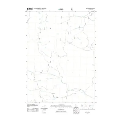
2011 Map of Ibex Peak
USGS Topo · Published 2011About this map
Ibex Peak anchors this high-elevation landscape in Cassia County, defined by a complex network of springs and drainages that supported remote ranching operations. The terrain is marked by essential passes and canyons, including Beaverdam Pass and Johnnys Canyon, which provided transit through the steep topography. Grounded in the region's agricultural and extractive history, the map shows several established ranch sites like Frish Ranch and Dry Gulch Ranch, as well as the Worthington Mine tucked into N E Canyon. Water is the most pervasive feature on this sheet, with dozens of named sources such as Mabey Spring, Lone Pine Spring, and Twin Springs feeding the headwaters of Beaverdam Creek and its many forks. This 2011 survey captures the enduring character of these rural highlands, where seasonal water sources and corrals like Wards Corral dictated the movement of livestock and people.
Find a feature on this map
42 named features on this map. Tap any name to fly to it.
Don’t see what you’re looking for? This feature index may not catch every label — zoom into the map to look around manually.
Map Details
Editions of this 2011 Ibex Peak Map
This is the sole edition of this map. No revisions or reprints were ever made.
Other maps of this area

1954 · Pocatello
USGS Topo · 1:250,000

1954 · Brigham City
USGS Topo · 1:250,000

1955 · Twin Falls
USGS Topo · 1:250,000

1955 · Wells
USGS Topo · 1:250,000

1958 · Wells
USGS Topo · 1:250,000

1958 · Twin Falls
USGS Topo · 1:250,000

1958 · Pocatello
USGS Topo · 1:250,000

1958 · Brigham City
USGS Topo · 1:250,000
1959 · Cotton Thomas Basin
USGS Topo · 1:62,500

1961 · Wells
USGS Topo · 1:250,000