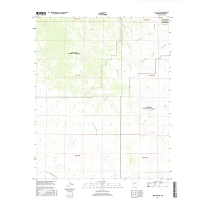
2017 Map of Ice Caves SE
USGS Topo · Published 2017About this map
El Malpais National Monument dominates this New Mexico landscape, preserving a massive volcanic field where rugged lava flows and cinder cones meet the surrounding high desert. The survey highlights a significant portion of the Continental Divide National Scenic Trail as it snakes across the southwestern corner of the sheet, tracing the backbone of the American West. Cutting through the jagged basalt and sandstone formations is the distinctive Hole-In-The-Wall trail, which provides passage through a corridor of older terrain surrounded by younger lava beds. The map illustrates the complex Public Land Survey System boundaries across townships like t7n r12w and t8n r11w, reflecting the intersection of federal conservation land and Western land management in Cibola County.
Find a feature on this map
9 named features on this map. Tap any name to fly to it.
Don’t see what you’re looking for? This feature index may not catch every label — zoom into the map to look around manually.
Map Details
Editions of this 2017 Ice Caves SE Map
This is the sole edition of this map. No revisions or reprints were ever made.
Other maps of this area
1917 · Broom Mountain
USGS Topo · 1:125,000

1954 · Saint Johns
USGS Topo · 1:250,000

1954 · Socorro
USGS Topo · 1:250,000

1957 · Saint Johns
USGS Topo · 1:250,000

1958 · Socorro
USGS Topo · 1:250,000

1958 · Saint Johns
USGS Topo · 1:250,000
1961 · North Pasture
USGS Topo · 1:24,000
1961 · Arrosa Ranch
USGS Topo · 1:24,000
1962 · Socorro
USGS Topo · 1:250,000

1962 · Saint Johns
USGS Topo · 1:250,000