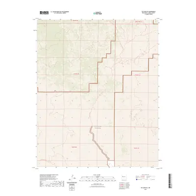
2023 Map of Ice Caves SE
USGS Topo · Published 2023About this map
West Malpais Wilderness dominates this corner of the high desert, protecting a landscape defined by expansive lava flows and traditional land divisions. The map documents a rugged volcanic terrain where human passage is marked primarily by long-distance paths rather than modern infrastructure. Two major routes intersect this wilderness: the Continental Divide National Scenic Trail and the local Hole-In-The-Wall Trail, which winds through the central sections of the quadrangle. These trails provide the primary access to the interior, reflecting the area's transition from historic ranching and timber use to modern conservation and backcountry recreation. The presence of these specific trails against the backdrop of the lava fields provides a clear record of how this portion of New Mexico is navigated today.
Find a feature on this map
9 named features on this map. Tap any name to fly to it.
Don’t see what you’re looking for? This feature index may not catch every label — zoom into the map to look around manually.
Map Details
Editions of this 2023 Ice Caves SE Map
This is the sole edition of this map. No revisions or reprints were ever made.
Other maps of this area

1917 · Broom Mountain
USGS Topo · 1:125,000

1954 · Saint Johns
USGS Topo · 1:250,000

1954 · Socorro
USGS Topo · 1:250,000

1957 · Saint Johns
USGS Topo · 1:250,000

1958 · Socorro
USGS Topo · 1:250,000

1958 · Saint Johns
USGS Topo · 1:250,000
1961 · North Pasture
USGS Topo · 1:24,000
1961 · Arrosa Ranch
USGS Topo · 1:24,000

1962 · Socorro
USGS Topo · 1:250,000

1962 · Saint Johns
USGS Topo · 1:250,000