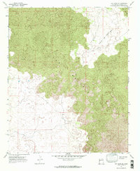
1967 Map of Ice Caves SE
USGS Topo · Published 1971About this map
Lava flows dominate this 1967 field survey of the high desert of Valencia County, revealing the stark geological transitions of the Zuni-Bandera volcanic field. The most prominent feature is the extensive reach of The Malpais, an expansive area of dark, solidified rock that occupies the center and southern portions of the quadrangle. Interspersed within these volcanic fields are lighter geographic pockets, most notably the aptly named Hole-In-The-Wall in the northeastern quadrant. This feature represents an island of older ground or soil surrounded by younger flows, creating a distinct topographical break in the landscape. The map illustrates how these volcanic formations dictated the location of unimproved dirt roads and trails, which wind around the edges of the jagged terrain rather than cutting directly through it.
Find a feature on this map
3 named features on this map. Tap any name to fly to it.
Don’t see what you’re looking for? This feature index may not catch every label — zoom into the map to look around manually.
Map Details
Editions of this 1967 Ice Caves SE Map
This is the sole edition of this map. No revisions or reprints were ever made.
Other maps of this area

1917 · Broom Mountain
USGS Topo · 1:125,000

1954 · Saint Johns
USGS Topo · 1:250,000

1954 · Socorro
USGS Topo · 1:250,000

1957 · Saint Johns
USGS Topo · 1:250,000

1958 · Socorro
USGS Topo · 1:250,000

1958 · Saint Johns
USGS Topo · 1:250,000
1961 · North Pasture
USGS Topo · 1:24,000
1961 · Arrosa Ranch
USGS Topo · 1:24,000

1962 · Socorro
USGS Topo · 1:250,000

1962 · Saint Johns
USGS Topo · 1:250,000