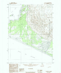
1985 Map of Icy Bay D-1
USGS Topo · Published 1985About this map
Malaspina Glacier dominates the eastern expanse of this coastal landscape, showing a complex network of terminal moraines and glacial flows where the ice meets the sea. This mid-1980s provisional survey captures a dynamic environment where the Wrangell-Saint Elias National Park and Wrangell-Saint Elias Wilderness protect the transition from high-altitude ice fields to the tidal waters of Icy Bay. The intricate drainage patterns of the Yahtse River and Caetani River reflect the constant shift of outwash plains and sediment. Along the southern edge, the coastline meets the Gulf of Alaska, with the map noting where the Boundary Follows Shoreline. Notable offshore features like Gull Island stand as landmarks in the bay, providing critical reference points in an area defined by glacial retreat and riverine sediment deposit.
Find a feature on this map
12 named features on this map. Tap any name to fly to it.
Don’t see what you’re looking for? This feature index may not catch every label — zoom into the map to look around manually.
Map Details
Editions of this 1985 Icy Bay D-1 Map
This is the sole edition of this map. No revisions or reprints were ever made.
Other maps of this area

1948 · Icy Bay D-2 and D-3
USGS Topo · 1:63,360

1950 · Bering Glacier
USGS Topo · 1:250,000

1950 · Icy Bay
USGS Topo · 1:250,000

1951 · Icy Bay D-2 and D-3
USGS Topo · 1:63,360

1951 · Icy Bay
USGS Topo · 1:250,000

1951 · Bering Glacier
USGS Topo · 1:250,000

1951 · Bering Glacier A-2
USGS Topo · 1:63,360

1951 · Yakutat
USGS Topo · 1:250,000

1951 · Mt Saint Elias
USGS Topo · 1:250,000

1959 · Yakutat
USGS Topo · 1:250,000