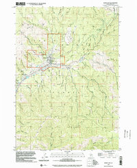
1998 Map of Idaho City
USGS Topo · Published 2002About this map
Idaho City serves as the focal point of this late-twentieth-century study, situated at the confluence of several prominent gulches within the Boise Basin. The landscape is heavily marked by its mining legacy, with the Gold Hill Mine and extensive tailings deposits surrounding the townsite and stretching along the banks of Mores Creek. This era of the landscape shows a transition toward forestry and scientific land management, evidenced by the presence of the Boise Basin Experiment Sta and the vast Boise National Forest boundaries. Local history and genealogy are preserved at the Boot Hill Cem, while the town's infrastructure includes a Landing Strip and a Water Tank. Numerous watercourses, including Thorn Creek, Bannock Creek, and Grayback Gulch, dissect the terrain, highlighting the intricate drainage system that once supported hydraulic mining operations in the region.
Find a feature on this map
68 named features on this map. Tap any name to fly to it.
Don’t see what you’re looking for? This feature index may not catch every label — zoom into the map to look around manually.
Map Details
Editions of this 1998 Idaho City Map
This is the sole edition of this map. No revisions or reprints were ever made.
Other maps of this area

1894 · Idaho Basin
USGS Topo · 1:125,000

1955 · Hailey
USGS Topo · 1:250,000

1957 · Placerville
USGS Topo · 1:24,000

1957 · Pioneerville
USGS Topo · 1:24,000

1957 · Warm Springs Point
USGS Topo · 1:24,000

1957 · Idaho City
USGS Topo · 1:24,000

1959 · Hailey
USGS Topo · 1:250,000

1962 · Hailey
USGS Topo · 1:250,000

1964 · Twin Springs
USGS Topo · 1:24,000

1969 · Dunnigan Creek
USGS Topo · 1:24,000