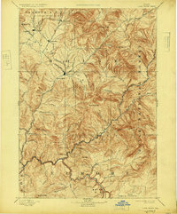
1894 Map of Idaho City
USGS Topo · Published 1947About this map
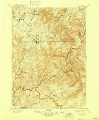
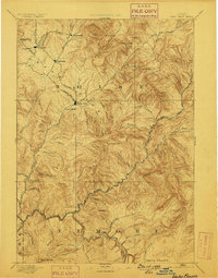
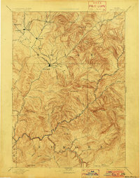
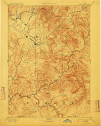
Idaho City sits at the heart of this 1892 reconnaissance survey, surrounded by the gold-rush era settlements of the Boise Basin. The map details a network of mining camps and supply points including Quartzburg, Placerville, and Pioneerville, linked by primitive roads and drainages such as Grimes Creek and Mores Creek. To the south and east, the terrain transitions into the high ridges and steep canyons of the Boise National Forest, punctuated by peaks like Wilson Peak and Thorn Creek Mtn.. The southern portion of the sheet is dominated by the South Fork Boise River, which carves through the landscape near Smith Prairie. This map captures the region's topography before modern development, showing isolated outposts like Halfway House and the thermal waters of Warm Springs, reflecting a landscape shaped by mineral extraction and early mountain transit.
Find a feature on this map
57 named features on this map. Tap any name to fly to it.
Don’t see what you’re looking for? This feature index may not catch every label — zoom into the map to look around manually.
Map Details
Editions of this 1894 Idaho City Map
7 editions found

Other maps of this area

1891 · Bear Valley
USGS Topo · 1:125,000

1892 · Mountain Home
USGS Topo · 1:125,000

1892 · Boise
USGS Topo · 1:125,000

1892 · Bisuka
USGS Topo · 1:125,000

1892 · Camas Prairie
USGS Topo · 1:125,000

1893 · Mountain Home
USGS Topo · 1:125,000

1893 · Bear Valley
USGS Topo · 1:125,000

1893 · Camas Prairie
USGS Topo · 1:125,000

1894 · Bisuka
USGS Topo · 1:125,000

1894 · Squaw Creek
USGS Topo · 1:125,000