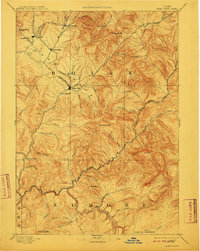
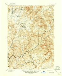
1894 Map of Idaho Basin
USGS Topo · Published 1910About this map
Idaho City stands as the central hub of this late 19th-century reconnaissance of the Idaho Basin, a region defined by its rugged topography and early mining infrastructure. Surveyed in 1892, the map documents a cluster of significant settlements including Placerville, Centerville, and Pioneerville, all interconnected by a network of gulches and creeks that drove the local economy. The drainage patterns of Mores Creek and Grimes Creek are charted in high detail, illustrating how the landscape dictated the placement of sites like Warm Springs and the Halfway House. To the southeast, the terrain opens into Smith Prairie near the confluence of the North Fork Boise River and Middle Fork Boise River. The placement of Quartzburg and numerous named gulches like Slaughter House Gulch and Ophir Creek provides a clear view of the territorial era's footprint before later development reshaped these mountain communities.
Find a feature on this map
58 named features on this map. Tap any name to fly to it.
Don’t see what you’re looking for? This feature index may not catch every label — zoom into the map to look around manually.
Map Details
Editions of this 1894 Idaho Basin Map
7 editions found


Other maps of this area

1891 · Bear Valley
USGS Topo · 1:125,000

1892 · Mountain Home
USGS Topo · 1:125,000

1892 · Boise
USGS Topo · 1:125,000

1892 · Bisuka
USGS Topo · 1:125,000

1892 · Camas Prairie
USGS Topo · 1:125,000

1893 · Mountain Home
USGS Topo · 1:125,000

1893 · Bear Valley
USGS Topo · 1:125,000

1893 · Camas Prairie
USGS Topo · 1:125,000

1894 · Bisuka
USGS Topo · 1:125,000

1894 · Squaw Creek
USGS Topo · 1:125,000