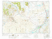
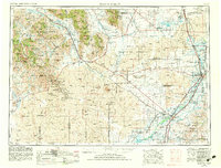
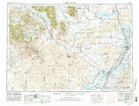
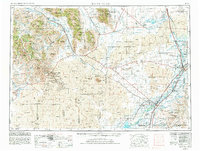
1955 Map of Idaho Falls
USGS Topo · Published 1963About this map
The Snake River valley and its surrounding high desert define this mid-century landscape, anchored by the burgeoning regional hub of Idaho Falls. To the west, the volcanic geology of the Craters Of the Moon National Monument contrasts with the massive, industrial footprint of the National Reactor Testing Station, a critical site of Cold War-era energy research. The map illustrates a complex water management system essential for agriculture in the arid Snake River Plain, showing the network of canals and reservoirs such as Mackay Reservoir and American Falls Reservoir. In the rugged terrain to the northwest, the White Knob Mountains and Pioneer Mountains loom over mining operations like the Empire Mine and Copper Basin Mine. Along the eastern edge, the Union Pacific railroad corridor connects established agricultural towns like Blackfoot and Shelley within the Fort Hall Indian Reservation.
Find a feature on this map
95 named features on this map. Tap any name to fly to it.
Don’t see what you’re looking for? This feature index may not catch every label — zoom into the map to look around manually.
Map Details
Editions of this 1955 Idaho Falls Map
5 editions found