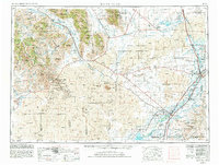
1955 Map of Idaho Falls
USGS Topo · Published 1991About this map
The Idaho National Engineering Laboratory dominates the central high desert, a vast facility surrounded by extensive lava fields and prominent landmarks like Big Southern Butte. To the west, the landscape shifts abruptly into the high peaks of the White Knob Mountains and Lost River Range, where the Big Lost River flows toward its sinks. This mid-century view documents a complex water management system of canals and ditches, such as the Burgess Canal and Idaho Canal, which transformed the eastern valley into a productive agricultural corridor for settlements like Blackfoot and Shelley.
Find a feature on this map
151 named features on this map. Tap any name to fly to it.
Don’t see what you’re looking for? This feature index may not catch every label — zoom into the map to look around manually.
Map Details
Editions of this 1955 Idaho Falls Map
5 editions found

Other maps of this area

1895 · Hailey
USGS Topo · 1:125,000

1897 · Hailey
USGS Topo · 1:125,000

1917 · Portneuf
USGS Topo · 1:62,500

1918 · Paradise Valley
USGS Topo · 1:62,500

1924 · Ammon
USGS Topo · 1:62,500

1929 · Bayhorse
USGS Topo · 1:125,000

1934 · American Falls
USGS Topo · 1:62,500

1934 · Michaud
USGS Topo · 1:62,500

1935 · MacKay
USGS Topo · 1:96,000

1935 · Borah Peak
USGS Topo · 1:125,000