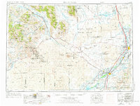
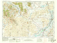
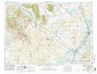
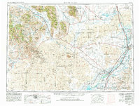
1955 Map of Idaho Falls
USGS Topo · Published 1976About this map
Big Southern Butte and a series of volcanic landmarks dominate the high desert floor between the Snake River and the mountain ranges to the west. This mid-century survey documents the expansive National Reactor Testing Station during a period of significant federal activity, juxtaposed against the preserved volcanic formations of Craters of the Moon National Monument. The settlement pattern follows the life-giving waters of the Big Lost River and the eastern agricultural corridor near Blackfoot and Idaho Falls. Along the western edge, the White Knob Mountains and Pioneer Mountains are marked by isolated operations like the Star Hope Mine and Copper Basin Mine. The rail infrastructure of the Union Pacific serves the valley, connecting small communities like Atomic City, Taber, and Moreland to the larger irrigation systems of the American Falls Reservoir.
Find a feature on this map
202 named features on this map. Tap any name to fly to it.
Don’t see what you’re looking for? This feature index may not catch every label — zoom into the map to look around manually.
Map Details
Editions of this 1955 Idaho Falls Map
5 editions found

Other maps of this area

1895 · Hailey
USGS Topo · 1:125,000

1897 · Hailey
USGS Topo · 1:125,000
1917 · Portneuf
USGS Topo · 1:62,500
1918 · Paradise Valley
USGS Topo · 1:62,500

1924 · Ammon
USGS Topo · 1:62,500

1929 · Bayhorse
USGS Topo · 1:125,000

1934 · American Falls
USGS Topo · 1:62,500

1934 · Michaud
USGS Topo · 1:62,500

1935 · MacKay
USGS Topo · 1:96,000

1935 · Borah Peak
USGS Topo · 1:125,000