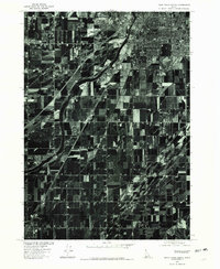
1976 Map of Idaho Falls South
USGS Topo · Published 1981About this map
Agricultural fields and irrigation networks dominate this 1976 orthophotoquad, showcasing the intensive land use south of Idaho Falls. The Snake River bisects the landscape, its winding course serving as the primary lifeline for the region's farming economy. Parallel to the river, the Great Western Canal underscores the complex engineering required to distribute water across the high desert plain. In the northern reaches, the expanding footprint of Shelly provides a clear view of mid-century rural settlement patterns as the town grew in tandem with the surrounding agricultural industry. This aerial perspective captures the precise geometric layout of field boundaries and transport corridors before the further suburbanization of the late twentieth century.
Find a feature on this map
3 named features on this map. Tap any name to fly to it.
Don’t see what you’re looking for? This feature index may not catch every label — zoom into the map to look around manually.
Map Details
Editions of this 1976 Idaho Falls South Map
This is the sole edition of this map. No revisions or reprints were ever made.
Other maps of this area

1924 · Ammon
USGS Topo · 1:62,500

1948 · Woodville
USGS Topo · 1:24,000

1948 · Idaho Falls North
USGS Topo · 1:24,000

1948 · Idaho Falls South
USGS Topo · 1:24,000

1948 · Ucon
USGS Topo · 1:24,000

1949 · Ucon
USGS Topo · 1:24,000

1949 · Idaho Falls North
USGS Topo · 1:24,000

1949 · Roberts
USGS Topo · 1:62,500

1949 · Shattuck Butte
USGS Topo · 1:24,000

1950 · Shattuck Butte
USGS Topo · 1:24,000