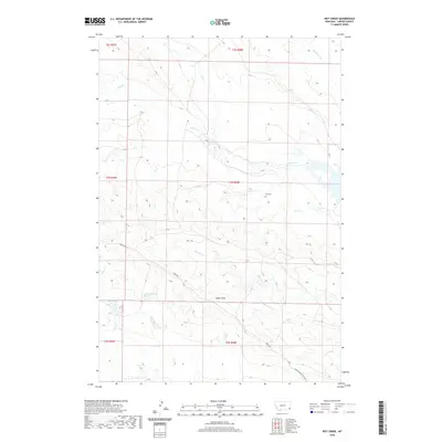
2020 Map of Ikey Creek
USGS Topo · Published 2020About this map
Elgin Cem stands as a lonely historical marker in this drainage-carved corner of Carter County, situated between the upper reaches of Cabin Creek and Lome Cr. The landscape is defined by an intricate network of intermittent waterways including McCarty Cr, Chito Cr, and the uniquely named Dead Boy Cr. These dry-creek beds and draws suggest a region dominated by seasonal water flow and high-plains ranching activity. A few critical paths such as Ridge Rd and the Ridgway Ridge Spur Rd traverse the high ground, providing the primary infrastructure for this sparsely populated territory. The presence of the 03N58E31CDD 01 Spring and Ewalt Draw further illustrates the essential relationship between local geography and the precious water sources required for life in the Montana backcountry.
Find a feature on this map
20 named features on this map. Tap any name to fly to it.
Don’t see what you’re looking for? This feature index may not catch every label — zoom into the map to look around manually.
Map Details
Editions of this 2020 Ikey Creek Map
This is the sole edition of this map. No revisions or reprints were ever made.
Other maps of this area

1954 · Ekalaka
USGS Topo · 1:250,000

1956 · Ekalaka
USGS Topo · 1:250,000

1958 · Ekalaka
USGS Topo · 1:250,000

1965 · Ekalaka
USGS Topo · 1:250,000
1979 · Dutchman Creek
USGS Topo · 1:24,000
1979 · Dead Boy Divide
USGS Topo · 1:24,000
1979 · Ikey Creek
USGS Topo · 1:24,000
1979 · Chalk Buttes
USGS Topo · 1:24,000
1980 · Taylor Hills
USGS Topo · 1:24,000
1980 · Prairie Dog Creek
USGS Topo · 1:24,000