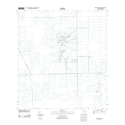
2012 Map of Immokalee SW
USGS Topo · Published 2012About this map
Ave Maria and its surrounding landscape reflect the recent planned development of this Collier County interior. The community is anchored by Ave Maria University, with residential streets like Avila Ave and Milano St branching out from the central campus. The map reveals a highly structured environment defined by right-angled drainage and agricultural canals, a stark contrast to the natural depressions of Cox Lake and Brown Lake. Transportation is dictated by historical grid-lines and utility routes, including the long stretches of Oil Well Rd and Pacific Grade Rd. Further east, the terrain transitions into the wetlands of the Big Cypress region, featuring isolated rises like Smallwood Island. This survey captures the town in its early growth phase, showing the intersection of new academic infrastructure with the traditional ranching and citrus landscape along Ranch 1 Rd.
Find a feature on this map
27 named features on this map. Tap any name to fly to it.
Don’t see what you’re looking for? This feature index may not catch every label — zoom into the map to look around manually.
Map Details
Editions of this 2012 Immokalee SW Map
This is the sole edition of this map. No revisions or reprints were ever made.
Other maps of this area

1956 · West Palm Beach
USGS Topo · 1:250,000

1957 · West Palm Beach
USGS Topo · 1:250,000

1958 · West Palm Beach
USGS Topo · 1:250,000

1958 · Corkscrew SE
USGS Topo · 1:24,000

1958 · Catherine Island
USGS Topo · 1:24,000

1958 · Immokalee
USGS Topo · 1:24,000

1958 · Sunniland
USGS Topo · 1:24,000

1958 · Belle Meade NE
USGS Topo · 1:24,000

1958 · Immokalee NE
USGS Topo · 1:24,000

1958 · Immokalee SW
USGS Topo · 1:24,000