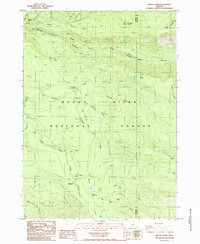
1985 Map of Imnaha Creek
USGS Topo · Published 1986About this map
The Rogue River National Forest defines this high-elevation landscape along the border of Jackson and Klamath counties. This 1980s survey captures a wilderness managed for both natural resources and recreation, centered on the confluence of the North Fork and the Middle Fork Rogue River. These waterways, including the deep Middle Fork Rogue River Canyon, serve as the primary drainage for the area's complex hydrology. Human activity is concentrated around the Imnaha Forest Service Sta and several gravel pits, indicating the maintenance of forest roads like the Sumpter route. Notable landmarks include the King Spruce (Site) and distinct terrain features such as Mudjekeewis Mtn and Gopher Ridge. The presence of Mtn Beaver Meadow and Black Bear Swamp suggests a mosaic of specialized habitats among the timber.
Find a feature on this map
41 named features on this map. Tap any name to fly to it.
Don’t see what you’re looking for? This feature index may not catch every label — zoom into the map to look around manually.
Map Details
Editions of this 1985 Imnaha Creek Map
This is the sole edition of this map. No revisions or reprints were ever made.
Other maps of this area

1891 · Ashland
USGS Topo · 1:250,000

1893 · Ashland
USGS Topo · 1:250,000

1897 · Ashland
USGS Topo · 1:250,000

1955 · Rustler Peak
USGS Topo · 1:62,500

1955 · Pelican Butte
USGS Topo · 1:62,500

1955 · Medford
USGS Topo · 1:250,000

1956 · Prospect
USGS Topo · 1:62,500

1957 · Medford
USGS Topo · 1:250,000

1958 · Medford
USGS Topo · 1:250,000
1985 · Rustler Peak
USGS Topo · 1:24,000