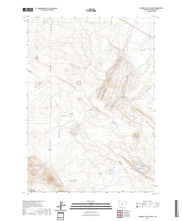
2024 Map of Imperial Valley South
USGS Topo · Published 2024About this map
High desert terrain and critical water resources dominate this portion of Deschutes County, where the landscape is defined by volcanic features and isolated watering points. Surface water is sparse, represented by seasonal features like Ram Lake and Mud Lake, along with vital man-made or improved points such as Meeks Waterhole, Rim Waterhole, and Nershal Well. These sites reveal the necessary infrastructure for ranching in an arid environment. The map shows a series of broad, flat expanses including Sunflower Flat, Braken Flat, and Johnson Flat, which are broken by prominent landmarks like Bronco Butte and the distinctive Coyote Rock. Human presence is minimal, anchored primarily by Frederick Butte Rd which traverses the western side of the quadrangle.
Find a feature on this map
22 named features on this map. Tap any name to fly to it.
Don’t see what you’re looking for? This feature index may not catch every label — zoom into the map to look around manually.
Map Details
Editions of this 2024 Imperial Valley South Map
This is the sole edition of this map. No revisions or reprints were ever made.
Other maps of this area

1955 · Crescent
USGS Topo · 1:250,000

1957 · Crescent
USGS Topo · 1:250,000

1958 · Crescent
USGS Topo · 1:250,000
1967 · Brothers
USGS Topo · 1:24,000

1970 · Crescent
USGS Topo · 1:250,000
1983 · Soldiers Cap
USGS Topo · 1:24,000

1983 · Hampton Butte
USGS Topo · 1:24,000

1983 · Imperial Valley South
USGS Topo · 1:24,000

1983 · Benjamin Lake
USGS Topo · 1:24,000

1983 · West of Hampton
USGS Topo · 1:24,000