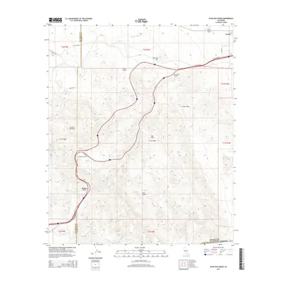
2015 Map of In-Ko-Pah Gorge
USGS Topo · Published 2015About this map
The Jacumba Mountains dominate this arid landscape, where steep elevation changes are carved by a complex network of dry washes and canyons. This 2015 U.S. Geological Survey topographic map documents the transition between the high desert peaks and the lower basins of Imperial County. Modern infrastructure is concentrated along the northern and western corridors, specifically where the In-Ko-Pah Gorge provides a natural, albeit challenging, passage for transportation. The settlement of Boulder Park sits near the San Diego County line, serving as a gateway to the high country. In the northeast, the terrain levels out near the Emory Ranch Airport and the edge of Ocotillo. Researchers can trace the alignment of historical transit routes, including Old Highway 80 and the Evan Hewes Hwy, as they navigate the dramatic slopes of Devils Canyon and the surrounding desert valleys like Davies Valley.
Find a feature on this map
28 named features on this map. Tap any name to fly to it.
Don’t see what you’re looking for? This feature index may not catch every label — zoom into the map to look around manually.
Map Details
Editions of this 2015 In-Ko-Pah Gorge Map
This is the sole edition of this map. No revisions or reprints were ever made.
Other maps of this area

1915 · El Centro
USGS Topo · 1:125,000

1931 · Carrizo
USGS Topo · 1:125,000

1939 · Jacumba
USGS Topo · 1:62,500

1940 · Plaster City
USGS Topo · 1:62,500

1940 · Coyote Wells
USGS Topo · 1:62,500

1942 · El Centro
USGS Topo · 1:250,000

1942 · Carrizo Mtn
USGS Topo · 1:62,500

1942 · Jacumba
USGS Topo · 1:62,500

1943 · Coyote Wells
USGS Topo · 1:62,500

1944 · Plaster City
USGS Topo · 1:62,500