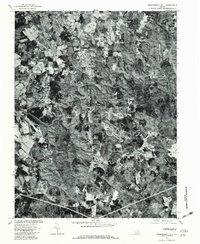
1977 Map of Independent Hill
USGS Topo · Published 1982About this map
The northern reaches of Manassas meet the winding corridors of the Occoquan River in this late 1970s orthophotoquad. This unique aerial perspective shows the transitional landscape of Prince William County, where established areas like Brentsville sit alongside the wooded drainage basins of Bull Run and Neabsco Creek. The visibility of land-clearing patterns and road networks provides a clear record of suburban expansion during this era, particularly around Longview and the crossroads at Independent Hill.
Find a feature on this map
12 named features on this map. Tap any name to fly to it.
Don’t see what you’re looking for? This feature index may not catch every label — zoom into the map to look around manually.
Map Details
Editions of this 1977 Independent Hill Map
This is the sole edition of this map. No revisions or reprints were ever made.
Other maps of this area

1890 · Mt. Vernon
USGS Topo · 1:125,000

1891 · Mt. Vernon
USGS Topo · 1:125,000

1894 · Warrenton
USGS Topo · 1:125,000

1894 · Mt. Vernon
USGS Topo · 1:125,000

1897 · Mt. Vernon
USGS Topo · 1:125,000

1915 · Fairfax
USGS Topo · 1:62,500

1927 · Quantico
USGS Topo · 1:62,500

1933 · Middleburg
USGS Topo · 1:62,500

1940 · Quantico
USGS Topo · 1:62,500

1943 · Quantico
USGS Topo · 1:62,500