1994 Map of Independent Hill
USGS Topo · Published 1998About this map
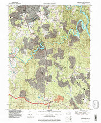
The City of Manassas boundary and the southern edges of its suburban expansion characterize this mid-1990s landscape. Residential developments like Georgetown South and Longview sit in contrast to the more secluded riverfront enclaves along the Occoquan River and Lake Jackson. The map captures a moment of transition where established rural communities such as Independent Hill and Brentsville meet modern infrastructure and large-scale preservation. To the south, the vast wooded buffers of Quantico Marine Corps Base and Prince William Forest Park create a permanent green break against the suburban corridor of Dale City. Local history is visible in the scattered family plots like Hixson Cem and recreational landmarks including the Old Dominion Speedway and the County Fairground.
Find a feature on this map
48 named features on this map. Tap any name to fly to it.
Don’t see what you’re looking for? This feature index may not catch every label — zoom into the map to look around manually.
Map Details
Editions of this 1994 Independent Hill Map
This is the sole edition of this map. No revisions or reprints were ever made.
Other maps of this area

1890 · Mt. Vernon
USGS Topo · 1:125,000

1891 · Mt. Vernon
USGS Topo · 1:125,000

1894 · Warrenton
USGS Topo · 1:125,000

1894 · Mt. Vernon
USGS Topo · 1:125,000

1897 · Mt. Vernon
USGS Topo · 1:125,000

1915 · Fairfax
USGS Topo · 1:62,500

1927 · Quantico
USGS Topo · 1:62,500

1933 · Middleburg
USGS Topo · 1:62,500

1940 · Quantico
USGS Topo · 1:62,500

1943 · Quantico
USGS Topo · 1:62,500