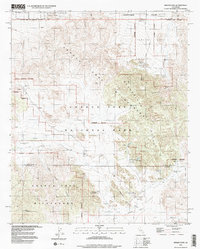
1995 Map of Indian Cove
USGS Topo · Published 1998About this map
Joshua Tree National Park and the surrounding high desert are documented here during a period of transition as wilderness boundaries were being refined in the late twentieth century. The map illustrates the convergence of recreational development and historical land use, with extensive camping facilities like Indian Cove Campground situated near older ranching and mining infrastructure. Industrial history is evident in the presence of the Wall Street Mill and Lang Mine, while the management of scarce water resources is highlighted by Barker Dam and Cow Camp Dam. The northern portion of the sheet shows the residential expansion of Panorama Heights near the Twentynine Palms Corporate Boundary. In the more isolated southern reaches, the Wonderland of Rocks and Lost Horse Valley reveal a landscape marked by ancient geologic formations and cultural sites, including Petroglyphs and early landmarks such as Samuelsons Rock.
Find a feature on this map
34 named features on this map. Tap any name to fly to it.
Don’t see what you’re looking for? This feature index may not catch every label — zoom into the map to look around manually.
Map Details
Editions of this 1995 Indian Cove Map
2 editions found
Other maps of this area

1941 · Edom
USGS Topo · 1:62,500

1944 · Edom
USGS Topo · 1:62,500

1944 · Pinyon Well
USGS Topo · 1:62,500

1947 · Santa Ana
USGS Topo · 1:250,000

1949 · Santa Ana
USGS Topo · 1:250,000

1953 · San Bernardino
USGS Topo · 1:250,000

1955 · Twentynine Palms
USGS Topo · 1:24,000

1955 · Twentynine Palms
USGS Topo · 1:62,500

1955 · Joshua Tree
USGS Topo · 1:62,500

1956 · San Bernardino
USGS Topo · 1:250,000
Featured Places
- Twentynine Palms, CA
- Panorama Heights, CA
- Joshua Tree, CA
- San Bernardino County, CA
- Riverside County, CA