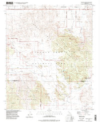
1995 Map of Indian Cove
USGS Topo · Published 1998About this map
Wonderland of Rocks dominates this desert landscape, where the geological formations of the High Desert meet early 20th-century mining and ranching history. The map documents a period when the Joshua Tree National Park boundaries were being refined, preserving a network of springs and man-made water catchments essential for survival in this arid environment. Significant cultural sites like the Petroglyphs and the Wall Street Mill are plotted alongside infrastructure such as the Indian Cove Ranger Station.
Find a feature on this map
37 named features on this map. Tap any name to fly to it.
Don’t see what you’re looking for? This feature index may not catch every label — zoom into the map to look around manually.
Map Details
Editions of this 1995 Indian Cove Map
2 editions found
Other maps of this area

1941 · Edom
USGS Topo · 1:62,500

1944 · Edom
USGS Topo · 1:62,500

1944 · Pinyon Well
USGS Topo · 1:62,500

1947 · Santa Ana
USGS Topo · 1:250,000

1949 · Santa Ana
USGS Topo · 1:250,000

1953 · San Bernardino
USGS Topo · 1:250,000

1955 · Twentynine Palms
USGS Topo · 1:24,000

1955 · Twentynine Palms
USGS Topo · 1:62,500

1955 · Joshua Tree
USGS Topo · 1:62,500

1956 · San Bernardino
USGS Topo · 1:250,000
Featured Places
- Twentynine Palms, CA
- Panorama Heights, CA
- Joshua Tree, CA
- San Bernardino County, CA
- Riverside County, CA