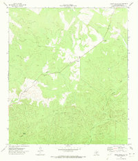
1971 Map of Indian Creek NE
USGS Topo · Published 1974About this map
Possum Spring and the headwaters of Indian Creek characterize this high-country landscape in Edwards County during the early 1970s. The topography is defined by deep incisions from drainage systems like Little Hackberry Draw and Possum Creek, where water access was a primary driver for human presence. The sparse settlement pattern is evidenced by an isolated Ranch and scattered infrastructure, including a Well and a Gravel Pit. Transport across this dissected terrain relies on a network of unpaved paths and a Jeep Trail, illustrating the remote nature of the Edwards Plateau before extensive modern development. This survey, compiled from 1970 aerial photography, documents the functional relationship between livestock ranching and the area's scarce water resources.
Find a feature on this map
8 named features on this map. Tap any name to fly to it.
Don’t see what you’re looking for? This feature index may not catch every label — zoom into the map to look around manually.
Map Details
Editions of this 1971 Indian Creek NE Map
This is the sole edition of this map. No revisions or reprints were ever made.
Other maps of this area

1893 · Rock Springs
USGS Topo · 1:125,000

1893 · Nueces
USGS Topo · 1:125,000

1896 · Nueces
USGS Topo · 1:125,000

1944 · Indian Creek
USGS Topo · 1:62,500

1947 · Hackberry
USGS Topo · 1:62,500

1954 · Sonora
USGS Topo · 1:250,000

1958 · Sonora
USGS Topo · 1:250,000

1958 · Del Rio
USGS Topo · 1:250,000

1964 · Del Rio
USGS Topo · 1:250,000
1971 · Ray Lake SE
USGS Topo · 1:24,000