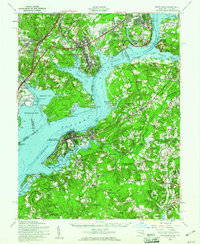
1956 Map of Indian Head
USGS Topo · Published 1961About this map
The Potomac River dominates this mid-century landscape, serving as a jurisdictional and industrial boundary between Northern Virginia and Southern Maryland. The Maryland shore is defined by federal installations and historic estates, notably the Indian Head Powder Factory and the Habre de Venture estate near Port Tobacco. On the Virginia side, the Fort Belvoir Military Reservation and the District of Columbia Department of Corrections occupy significant riverfront acreage, contrasting with the preservation of Gunston Hall. The map documents the rural character of the interior prior to heavy suburbanization, with small crossroads like Pomonkey and Marbury connected by routes such as Old Stage Road. Along Mattawoman Creek and Chicamuxen Creek, the marshy shoreline remains largely undeveloped, preserving a network of landings and wharves like Sanders Wharf and Proctors Wharf that reflect an older river-based economy.
Find a feature on this map
134 named features on this map. Tap any name to fly to it.
Don’t see what you’re looking for? This feature index may not catch every label — zoom into the map to look around manually.
Map Details
Editions of this 1956 Indian Head Map
2 editions found
Other maps of this area

1889 · Fredericksburg
USGS Topo · 1:125,000

1890 · Mt. Vernon
USGS Topo · 1:125,000

1891 · Mt. Vernon
USGS Topo · 1:125,000

1892 · Fredericksburg
USGS Topo · 1:125,000

1892 · Brandywine
USGS Topo · 1:62,500

1894 · Wicomico
USGS Topo · 1:62,500

1894 · Fredericksburg
USGS Topo · 1:125,000

1894 · Mt. Vernon
USGS Topo · 1:125,000

1895 · Wicomico
USGS Topo · 1:62,500

1895 · Brandywine
USGS Topo · 1:62,500