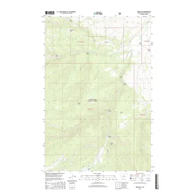
2017 Map of Indian Hill
USGS Topo · Published 2017About this map
The Middle Fork Judith River and South Fork Judith River converge in this high-elevation drainage of the Lewis & Clark National Forest. The landscape is defined by deep incisions like Dry Pole Canyon and Bower Canyon, which cut through the high ridges of the Little Belt Mountains. The nomenclature reflects a history of early ranching and livestock movement, with features such as Woodchopper Ridge, Ettien Ridge, and Kelly Coulee likely bearing the names of early settlers or local work camps. The area is marked by significant topographical relief, rising toward Indian Hill and the prominent Russell Point. Modern access is limited to unpaved tracks like Pig Eye Rd and Middlefork Rd, which trace the same paths used for decades to navigate these remote watersheds and the Judith River headwaters.
Find a feature on this map
30 named features on this map. Tap any name to fly to it.
Don’t see what you’re looking for? This feature index may not catch every label — zoom into the map to look around manually.
Map Details
Editions of this 2017 Indian Hill Map
This is the sole edition of this map. No revisions or reprints were ever made.
Other maps of this area

1886 · Little Belt Mts.
USGS Topo · 1:250,000

1894 · Little Belt Mts.
USGS Topo · 1:250,000

1897 · Little Belt Mts.
USGS Topo · 1:250,000

1898 · Little Belt Mts.
USGS Topo · 1:250,000

1902 · Little Belt Mts.
USGS Topo · 1:250,000

1948 · White Sulphur Springs
USGS Topo · 1:250,000

1958 · White Sulphur Springs
USGS Topo · 1:250,000

1961 · White Sulphur Springs
USGS Topo · 1:250,000

1965 · White Sulphur Springs
USGS Topo · 1:250,000
1970 · Woodhurst Mountain
USGS Topo · 1:24,000