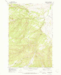
1970 Map of Indian Hill
USGS Topo · Published 1973About this map
Lewis and Clark National Forest encompasses this high mountain landscape, where the Judith River cuts through the eastern edge of the quadrangle. In the early 1970s, this area served as a hub for both forest management and recreation, anchored by the Judith Ranger Sta and seasonal sites like Indian Hill Campground and Dry Pole Campground. The terrain is defined by prominent elevations such as Woodchopper Ridge and Ettien Ridge, which are traversed by a network of pack and jeep trails rather than paved roads. A series of deep drainages, including Yogo Creek and Dry Pole Canyon, illustrate the complex drainage patterns feeding the Judith Basin. The presence of a Gaging Sta and a Gravel Pit indicates a landscape that was actively monitored and utilized for local infrastructure, while the Yogo Crossing provides a specific point of historical access across the high-country creeks.
Find a feature on this map
32 named features on this map. Tap any name to fly to it.
Don’t see what you’re looking for? This feature index may not catch every label — zoom into the map to look around manually.
Map Details
Editions of this 1970 Indian Hill Map
This is the sole edition of this map. No revisions or reprints were ever made.
Other maps of this area

1886 · Little Belt Mts.
USGS Topo · 1:250,000

1894 · Little Belt Mts.
USGS Topo · 1:250,000

1897 · Little Belt Mts.
USGS Topo · 1:250,000

1898 · Little Belt Mts.
USGS Topo · 1:250,000

1902 · Little Belt Mts.
USGS Topo · 1:250,000

1948 · White Sulphur Springs
USGS Topo · 1:250,000

1958 · White Sulphur Springs
USGS Topo · 1:250,000

1961 · White Sulphur Springs
USGS Topo · 1:250,000

1965 · White Sulphur Springs
USGS Topo · 1:250,000
1970 · Woodhurst Mountain
USGS Topo · 1:24,000