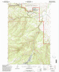
1995 Map of Indian Hill
USGS Topo · Published 1997About this map
Lewis and Clark National Forest dominates this mid-1990s landscape, where the confluence of the South Fork Judith River and Middle Fork Judith River dictates the local geography. The map reveals a remote ranching and forest-service environment, characterized by the Judith Guard Station and established properties like Korells Dude Ranch and Trask Ranch. The terrain is defined by dramatic elevations including Woodchopper Ridge and Ettien Ridge, which are separated by a complex network of coulees and canyons.
Find a feature on this map
66 named features on this map. Tap any name to fly to it.
Don’t see what you’re looking for? This feature index may not catch every label — zoom into the map to look around manually.
Map Details
Editions of this 1995 Indian Hill Map
This is the sole edition of this map. No revisions or reprints were ever made.
Other maps of this area

1886 · Little Belt Mts.
USGS Topo · 1:250,000

1894 · Little Belt Mts.
USGS Topo · 1:250,000

1897 · Little Belt Mts.
USGS Topo · 1:250,000

1898 · Little Belt Mts.
USGS Topo · 1:250,000

1902 · Little Belt Mts.
USGS Topo · 1:250,000

1948 · White Sulphur Springs
USGS Topo · 1:250,000

1958 · White Sulphur Springs
USGS Topo · 1:250,000

1961 · White Sulphur Springs
USGS Topo · 1:250,000

1965 · White Sulphur Springs
USGS Topo · 1:250,000
1970 · Woodhurst Mountain
USGS Topo · 1:24,000