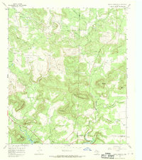
1967 Map of Indian Mountain
USGS Topo · Published 1970About this map
Indian Mountain and a cluster of neighboring summits dominate this 1960s landscape at the intersection of Young, Jack, and Palo Pinto counties. The terrain is defined by its dramatic relief, from the heights of Cement Mountain and Shin Oak Mountain down to the southern shoreline of Possum Kingdom Lake. This era shows a landscape undergoing industrial change, with a network of pipelines and numerous Oil Wells scattered across the valleys, including the Ross Valley Creek and Connor Creek drainages. Genealogy researchers can locate the Center Ridge Cem in the northwest and another Cem near the confluence of Rock Creek and Dillingham Creek. The map documents a rugged rural interior where traditional landmarks like Pitts Mountain coexist with mid-century infrastructure like Radio Towers and a local Gas Plant.
Find a feature on this map
32 named features on this map. Tap any name to fly to it.
Don’t see what you’re looking for? This feature index may not catch every label — zoom into the map to look around manually.
Map Details
Editions of this 1967 Indian Mountain Map
This is the sole edition of this map. No revisions or reprints were ever made.
Other maps of this area

1893 · Nueces
USGS Topo · 1:125,000

1896 · Nueces
USGS Topo · 1:125,000

1944 · Barksdale
USGS Topo · 1:62,500

1944 · Indian Creek
USGS Topo · 1:62,500

1944 · Indian Mountain
USGS Topo · 1:62,500

1947 · Hackberry
USGS Topo · 1:62,500

1958 · Del Rio
USGS Topo · 1:250,000

1964 · Del Rio
USGS Topo · 1:250,000
1974 · Twomile Draw
USGS Topo · 1:24,000
1974 · Kelley Peak
USGS Topo · 1:24,000