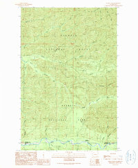
1990 Map of Indian Pass
USGS Topo · Published 1990About this map
The Bogachiel River corridor defines this remote stretch of Clallam County at the boundary of Olympic National Park and Olympic National Forest. The landscape is dominated by steep terrain including Rugged Ridge, where numerous seasonal and year-round streams such as Fahnestock Creek and Kloshe Boulevard Creek feed into the larger river systems. Historically significant as a point of transit through the high country, Indian Pass sits near the geographic center of the sheet, while the Bogachiel Ranger Station serves as the primary outpost for monitoring this wilderness. The map reveals the intricate drainage patterns of the South Fork Calawah River and Sitkum River, alongside a single industrial footprint at the Borrow Pit, illustrating the minimal human development in this protected Pacific Northwest environment during the late twentieth century.
Find a feature on this map
31 named features on this map. Tap any name to fly to it.
Don’t see what you’re looking for? This feature index may not catch every label — zoom into the map to look around manually.
Map Details
Editions of this 1990 Indian Pass Map
This is the sole edition of this map. No revisions or reprints were ever made.
Other maps of this area

1922 · Pysht
USGS Topo · 1:62,500

1935 · Lake Pleasant
USGS Topo · 1:62,500

1939 · Forks
USGS Topo · 1:62,500

1942 · Pysht
USGS Topo · 1:62,500

1942 · Lake Pleasant
USGS Topo · 1:62,500

1943 · Spruce Mountain
USGS Topo · 1:62,500

1943 · Copalis Beach
USGS Topo · 1:250,000

1951 · Copalis Beach
USGS Topo · 1:250,000

1953 · Cape Flattery
USGS Topo · 1:250,000

1956 · Spruce Mtn.
USGS Topo · 1:62,500