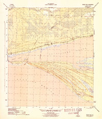
1945 Map of Indian Pass
USGS Topo · Published 1945About this map
St Vincent Island and the neighboring Indian Peninsula dominate this coastal survey, revealing the intricate barrier systems of the Florida panhandle during the mid-1940s. The landscape is defined by vast sand dunes and tidal waters like St Vincent Sound and Indian Lagoon, connected by the narrow Indian Pass. Along the mainland, the Apalachicola Northern railroad skirts the marshy interior, serving a series of mileage-named settlements such as Nine Mile, Eleven Mile, and Thirteen Mile. These small outposts, along with the village of Odena and the Odena Fire Tower, reflect a sparse but established regional network tied to the timber and coastal economy. On the southeastern tip of the island, the presence of Coast Guard Sta No 166 near Oyster Pond underscores the strategic maritime importance of the pass during the war era.
Find a feature on this map
20 named features on this map. Tap any name to fly to it.
Don’t see what you’re looking for? This feature index may not catch every label — zoom into the map to look around manually.
Map Details
Editions of this 1945 Indian Pass Map
4 editions found
Other maps of this area

1943 · Port St. Joe
USGS Topo · 1:31,680

1943 · Cape San Blas
USGS Topo · 1:31,680

1943 · West Pass
USGS Topo · 1:31,680

1943 · Indian Pass
USGS Topo · 1:24,000

1943 · Jackson River
USGS Topo · 1:24,000

1945 · Cape St. George
USGS Topo · 1:31,680

1945 · Lake Wimico
USGS Topo · 1:31,680

1945 · Jackson River
USGS Topo · 1:31,680

1945 · Indian Pass
USGS Topo · 1:31,680

1949 · Apalachicola
USGS Topo · 1:250,000