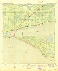
1945 Map of Indian Pass
USGS Topo · Published 1945About this map
St Vincent Island dominates the southern landscape of this 1943 survey, separated from the mainland by the waters of St Vincent Sound and the narrow Indian Pass. Along the coast and marshes, a string of numeric settlements including Nine Mile, Eleven Mile, and Thirteen Mile line the primary roadway, marking distances along the coastal corridor. To the north, the Apalachicola Northern railroad cuts through the terrain near the small settlement of Odena.
Find a feature on this map
20 named features on this map. Tap any name to fly to it.
Don’t see what you’re looking for? This feature index may not catch every label — zoom into the map to look around manually.
Map Details
Editions of this 1945 Indian Pass Map
4 editions found
Other maps of this area

1943 · Port St. Joe
USGS Topo · 1:31,680

1943 · Cape San Blas
USGS Topo · 1:31,680

1943 · West Pass
USGS Topo · 1:31,680

1943 · Indian Pass
USGS Topo · 1:24,000

1943 · Jackson River
USGS Topo · 1:24,000

1945 · Cape St. George
USGS Topo · 1:31,680

1945 · Lake Wimico
USGS Topo · 1:31,680

1945 · Jackson River
USGS Topo · 1:31,680

1945 · Indian Pass
USGS Topo · 1:31,680

1949 · Apalachicola
USGS Topo · 1:250,000