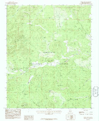
1986 Map of Indian Peak
USGS Topo · Published 1986About this map
Prescott National Forest dominates this Yavapai County landscape, revealing a complex network of high-elevation peaks and seasonal water sources in the mid-1980s. The topography is defined by prominent elevations such as Williams Mtn, Indian Peak, and the broad expanse of Juniper Mesa. This survey serves as a vital record of livestock and land management infrastructure, documenting numerous named tanks and springs essential for life in this arid environment, including Fritche Tank, Triangle U Tank, and Indian Springs. Drainage patterns are clearly marked by the winding courses of Walnut Creek and Apache Creek. One of the most distinctive geomorphic features is the depression known as The Sinks, located east of the central peaks, which suggests the presence of underlying limestone or volcanic activity common to this portion of the Arizona transition zone.
Find a feature on this map
30 named features on this map. Tap any name to fly to it.
Don’t see what you’re looking for? This feature index may not catch every label — zoom into the map to look around manually.
Map Details
Editions of this 1986 Indian Peak Map
This is the sole edition of this map. No revisions or reprints were ever made.
Other maps of this area

1886 · Chino
USGS Topo · 1:250,000

1887 · Prescott
USGS Topo · 1:250,000

1891 · Chino
USGS Topo · 1:250,000

1892 · Prescott
USGS Topo · 1:250,000

1947 · Simmons
USGS Topo · 1:62,500

1947 · Picacho Butte
USGS Topo · 1:62,500

1947 · Turkey Canyon
USGS Topo · 1:62,500

1947 · Camp Wood
USGS Topo · 1:62,500

1948 · Williams
USGS Topo · 1:250,000

1948 · Picacho Butte
USGS Topo · 1:63,360