1988 Map of Indian Springs
USGS Topo · Published 1988About this map
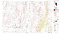
Indian Springs serves as the primary hub in this arid landscape where military reservations and conservation areas dominate the basin-and-range topography. The late 20th-century footprint of the Nellis Air Force Range and the Nellis Air Force Auxiliary Field defines the western and central sectors, including restricted zones like the Nellis Air Force Range (Area of Exclusion). These defense lands sit adjacent to the sprawling Desert National Wildlife Range, which preserves the high ridges of the Pintwater Range and the Sheep Range.
Find a feature on this map
67 named features on this map. Tap any name to fly to it.
Don’t see what you’re looking for? This feature index may not catch every label — zoom into the map to look around manually.
Map Details
Editions of this 1988 Indian Springs Map
This is the sole edition of this map. No revisions or reprints were ever made.
Other maps of this area

1885 · Pioche
USGS Topo · 1:250,000

1886 · Saint Thomas
USGS Topo · 1:250,000

1886 · Pioche
USGS Topo · 1:250,000

1893 · Saint Thomas
USGS Topo · 1:250,000

1907 · Las Vegas
USGS Topo · 1:250,000

1908 · Kawich
USGS Topo · 1:250,000

1908 · Furnace Creek
USGS Topo · 1:250,000

1908 · Las Vegas
USGS Topo · 1:250,000

1910 · Furnace Creek
USGS Topo · 1:250,000

1926 · Boulder Canyon
USGS Topo · 1:96,000