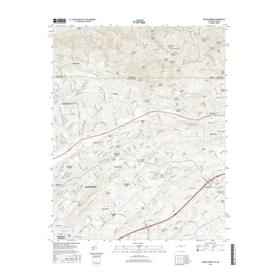
2016 Map of Indian Springs
USGS Topo · Published 2016About this map
The rolling landscape of northeast Tennessee and southwest Virginia is meticulously documented here, centered on the residential and industrial growth near Kingsport. This area, once dominated by small family settlements and agricultural operations, shows a modern network of roads like E Stone Dr and Bloomingdale Pike connecting established neighborhoods such as Bloomingdale, Orebank, and Gunnings. The terrain is characterized by a series of prominent ridges including Mullins Ridge and Chestnut Ridge, separated by namesake hollows like Sougan Hollow and Muddy Spring Hollow. Local history is anchored by numerous family cemeteries and country churches, such as the Arcadia United Methodist Church and the Emory Methodist Church, while the presence of Pettyjohn Mill and Huddle Mill points to the region's historic reliance on water power along tributaries like Full Cr and Fall Cr. The map also captures the Indian Springs Airport and the edges of Fort Patrick Henry Lake, reflecting the intersection of local aviation and the Tennessee Valley Authority’s regional water management.
Find a feature on this map
226 named features on this map. Tap any name to fly to it.
Don’t see what you’re looking for? This feature index may not catch every label — zoom into the map to look around manually.
Map Details
Editions of this 2016 Indian Springs Map
This is the sole edition of this map. No revisions or reprints were ever made.
Other maps of this area

1891 · Roan Mountain
USGS Topo · 1:125,000

1892 · Greeneville
USGS Topo · 1:125,000

1894 · Roan Mountain
USGS Topo · 1:125,000

1894 · Estillville
USGS Topo · 1:125,000

1896 · Greeneville
USGS Topo · 1:125,000

1897 · Bristol
USGS Topo · 1:125,000

1902 · Bristol
USGS Topo · 1:125,000

1904 · Roan Mountain
USGS Topo · 1:125,000

1904 · Greeneville
USGS Topo · 1:125,000

1935 · Hilton
USGS Topo · 1:24,000