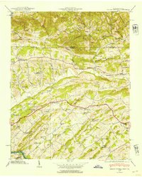
1939 Map of Indian Springs
USGS Topo · Published 1954About this map
Lee Highway cuts through the center of this Tennessee-Virginia borderland, serving as the primary corridor for a landscape defined by small agrarian communities and religious centers. In the years before massive suburban expansion, settlements like Bridwell Town and Indian Springs were anchored by neighborhood landmarks such as Cox Chapel, Cassady Ch, and Gunnings Academy. The map reveals the local economy of the late 1930s through specific industry markers, including the Ore Bank mining site and water-powered operations like Pettyjohn Mill and Huddle Mill on Fall Creek. The terrain is characterized by a series of parallel ridges, notably Vine Yard Ridge and Chestnut Ridge, which channeled settlement and transportation along the fertile creek bottoms of Reedy Creek and Boozy Creek. From the banks of the South Fork Holston River in the southwest to the Virginia Tennessee state line, the survey preserves the locations of numerous country schools, such as Shadylawn Sch and Cold Springs Sch, that once served these rural Sullivan County valleys.
Find a feature on this map
75 named features on this map. Tap any name to fly to it.
Don’t see what you’re looking for? This feature index may not catch every label — zoom into the map to look around manually.
Map Details
Editions of this 1939 Indian Springs Map
This is the sole edition of this map. No revisions or reprints were ever made.
Other maps of this area

1891 · Roan Mountain
USGS Topo · 1:125,000

1892 · Greeneville
USGS Topo · 1:125,000

1894 · Roan Mountain
USGS Topo · 1:125,000

1894 · Estillville
USGS Topo · 1:125,000

1896 · Greeneville
USGS Topo · 1:125,000

1897 · Bristol
USGS Topo · 1:125,000

1902 · Bristol
USGS Topo · 1:125,000

1904 · Roan Mountain
USGS Topo · 1:125,000

1904 · Greeneville
USGS Topo · 1:125,000

1935 · Hilton
USGS Topo · 1:24,000