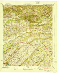
1940 Map of Indian Springs
USGS Topo · Published 1940About this map
Chestnut Ridge and the winding valley of Reedy Creek define the landscape along the Virginia Tennessee border just before the 1940s. This survey, conducted through a collaboration between the USGS and the Tennessee Valley Authority, captures a rural society organized around small crossroads settlements and community institutions. In the southern half of the sheet, the South Fork Holston River flows past industrial and agricultural markers like Pettyjohn Mill and Huddle Mill, while the central corridor is anchored by the Lee Highway. Educational life is well-documented through landmarks like Gunnings Academy and Cold Springs Sch, alongside a high density of country churches such as Harbor Chapel and Cox Chapel. The map is particularly useful for genealogists tracing family names in Bridwell Town, Ketrontown, and Thomas Heights.
Find a feature on this map
77 named features on this map. Tap any name to fly to it.
Don’t see what you’re looking for? This feature index may not catch every label — zoom into the map to look around manually.
Map Details
Editions of this 1940 Indian Springs Map
This is the sole edition of this map. No revisions or reprints were ever made.
Other maps of this area

1891 · Roan Mountain
USGS Topo · 1:125,000

1892 · Greeneville
USGS Topo · 1:125,000

1894 · Roan Mountain
USGS Topo · 1:125,000

1894 · Estillville
USGS Topo · 1:125,000

1896 · Greeneville
USGS Topo · 1:125,000

1897 · Bristol
USGS Topo · 1:125,000

1902 · Bristol
USGS Topo · 1:125,000

1904 · Roan Mountain
USGS Topo · 1:125,000

1904 · Greeneville
USGS Topo · 1:125,000

1935 · Hilton
USGS Topo · 1:24,000