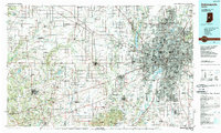
1953 Map of Indianapolis
USGS Topo · Published 1965About this map
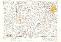
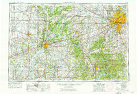
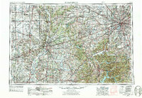
The White River and the Wabash River anchor this mid-century landscape of central Indiana and eastern Illinois, during an era defined by industrial expansion and military readiness. Major regional hubs like Indianapolis, Terre Haute, and Bloomington are shown with their corresponding infrastructures, including the Indiana University campus and the legendary motor racing hub of Speedway. The map details a dense network of major railroads like the Pennsylvania and New York Central, which supported heavy industry at sites such as the Wabash River Ordnance Works and the Terre Haute Ordnance Works. Public institutions and recreation areas are prominent, ranging from the Federal Penitentiary near Terre Haute to the natural expanses of Brown County State Park and Turkey Run State Park. This survey captures the transition of the Wabash Valley from a heavy industrial corridor to a region increasingly reliant on reservoirs like Mansfield Reservoir for water management and recreation.
Find a feature on this map
139 named features on this map. Tap any name to fly to it.
Don’t see what you’re looking for? This feature index may not catch every label — zoom into the map to look around manually.
Map Details
Editions of this 1953 Indianapolis Map
4 editions found

Historical Maps of Indianapolis Through Time
5 maps found