1953 Map of Indianapolis
USGS Topo · Published 1976About this map
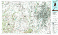
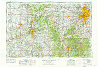
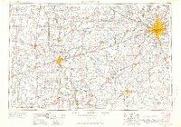
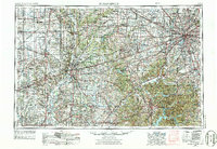
The central Indiana plains and the rugged terrain of the Brown County Hills define this mid-1970s view of the region, centered on the expanding metropolis of Indianapolis. Radiating from the capital, a network of transportation routes including the recently completed Interstate 465 loop connects suburban communities like Carmel, Zionsville, and Greenwood to the urban core. To the west, the Wabash River passes through the industrial hub of Terre Haute, while the White River winds southward through Martinsville toward Bloomington and the significant water volume of Monroe Lake.
Find a feature on this map
173 named features on this map. Tap any name to fly to it.
Don’t see what you’re looking for? This feature index may not catch every label — zoom into the map to look around manually.
Map Details
Editions of this 1953 Indianapolis Map
4 editions found

Historical Maps of Indianapolis Through Time
5 maps found