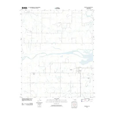
2010 Map of Indianola
USGS Topo · Published 2010About this map
The Canadian River dominates the central landscape of this Pittsburg County region, carving a wide path between the northern uplands and the southern settlements. To the south, the community of Indianola serves as a primary hub of local activity, featuring the Indianola Cemetery and a network of rural roads that connect the town to outlying areas. The settlement pattern is characterized by its reliance on water sources, with numerous creeks such as Mill Creek, Rock Creek, and Bald Mountain Creek draining the terrain. Near the center of the sheet, the Choate Prairie area includes the Choate Prairie Cemetery and the Oknoname 121014 Dam, illustrating the local efforts to manage water for agricultural or residential use. The map reveals a transition from river-bottom land to the more elevated prairie regions, connected by roads like Choate Prairie Rd and River Bottom Rd.
Find a feature on this map
34 named features on this map. Tap any name to fly to it.
Don’t see what you’re looking for? This feature index may not catch every label — zoom into the map to look around manually.
Map Details
Editions of this 2010 Indianola Map
This is the sole edition of this map. No revisions or reprints were ever made.
Other maps of this area

1900 · Canadian
USGS Topo · 1:125,000

1946 · Fort Smith
USGS Topo · 1:250,000

1962 · Raiford
USGS Topo · 1:24,000

1962 · Henryetta SW
USGS Topo · 1:24,000

1963 · Stidham
USGS Topo · 1:24,000

1965 · Fort Smith
USGS Topo · 1:250,000

1967 · Fort Smith
USGS Topo · 1:250,000
1971 · Crowder
USGS Topo · 1:24,000
1971 · Canadian
USGS Topo · 1:24,000
1971 · Lake Mc Alester
USGS Topo · 1:24,000