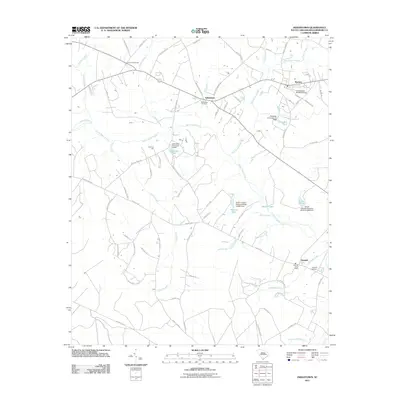
2011 Map of Indiantown
USGS Topo · Published 2011About this map
Black Mingo Creek and its many tributaries, including Turkey Creek and Gully Branch, weave through a landscape of low-lying wetlands and established rural crossroads. This 2011 survey of the Williamsburg County interior captures the layout of agricultural settlements and timberlands surrounding Indiantown and Nesmith. The geography is defined by a series of named swamps, such as Boggy Swamp and Paisley Swamp, which historically influenced the placement of roads and homesteads. Local heritage is rooted in locations like Indiantown Cemetery and the Nesmith Post Office, while the inclusion of the Hemingway-Stuckey Airport reflects the modernization of transportation in this primarily rural corridor. Smaller landmarks like Burrows Hall and several dammed water bodies, including Lakewood Pond and Snowden Pond, provide specific points of reference for family historians and researchers interested in the evolving land use of the South Carolina Coastal Plain.
Find a feature on this map
83 named features on this map. Tap any name to fly to it.
Don’t see what you’re looking for? This feature index may not catch every label — zoom into the map to look around manually.
Map Details
Editions of this 2011 Indiantown Map
This is the sole edition of this map. No revisions or reprints were ever made.
Other maps of this area

1943 · Henry
USGS Topo · 1:24,000

1943 · Rhems
USGS Topo · 1:24,000

1946 · Hyman
USGS Topo · 1:62,500

1946 · Johnsonville
USGS Topo · 1:62,500

1946 · Indiantown
USGS Topo · 1:62,500

1949 · Georgetown
USGS Topo · 1:250,000

1967 · Georgetown
USGS Topo · 1:250,000

1974 · Georgetown
USGS Topo · 1:250,000

1986 · Kingstree
USGS Topo · 1:100,000
1990 · Lake City East
USGS Topo · 1:24,000