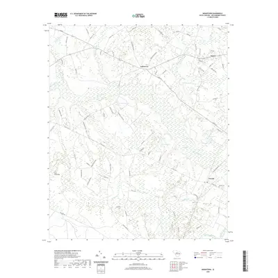
2020 Map of Indiantown
USGS Topo · Published 2020About this map
Black Mingo Creek and a network of riparian wetlands dominate this Williamsburg County landscape, where the settlements of Indiantown, Stuckey, and Nesmith are positioned along higher ground between extensive swamp systems. The geography is defined by numerous named water bodies, including Paisley Swamp, Boggy Swamp, and Campbell Swamp, which illustrate the hydrological complexity of the region. Local transit and land division are visible through a dense grid of secondary routes like Old Georgetown Road and Midway Road, reflecting a long history of rural residence and agricultural development. Genealogists and historians will find interest in localized landmarks such as the Nesmith Cemetery and distinct geological features like Pine Island Bay. The map also traces several private water features including Wilson Lake, Erwins Pond, and Browns Pond, indicating the historical importance of managed water for the local community and economy.
Find a feature on this map
81 named features on this map. Tap any name to fly to it.
Don’t see what you’re looking for? This feature index may not catch every label — zoom into the map to look around manually.
Map Details
Editions of this 2020 Indiantown Map
This is the sole edition of this map. No revisions or reprints were ever made.
Other maps of this area

1943 · Henry
USGS Topo · 1:24,000

1943 · Rhems
USGS Topo · 1:24,000

1946 · Hyman
USGS Topo · 1:62,500

1946 · Johnsonville
USGS Topo · 1:62,500

1946 · Indiantown
USGS Topo · 1:62,500

1949 · Georgetown
USGS Topo · 1:250,000

1967 · Georgetown
USGS Topo · 1:250,000

1974 · Georgetown
USGS Topo · 1:250,000

1986 · Kingstree
USGS Topo · 1:100,000
1990 · Lake City East
USGS Topo · 1:24,000