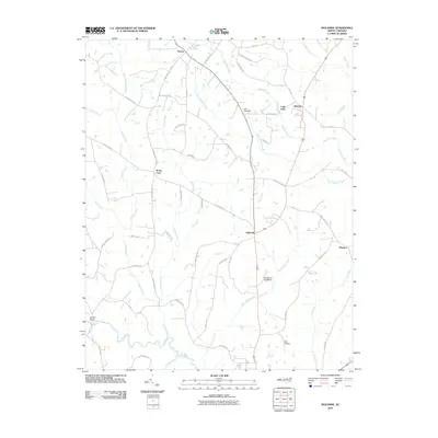
2010 Map of Ingleside
USGS Topo · Published 2010About this map
Ingleside and the surrounding agricultural landscape of northern Franklin County are defined by a dense network of family-named roads and rural communities as they appeared in 2010. The settlement patterns in this area follow the high ground between the numerous tributaries that feed the Tar River, which winds across the southwestern corner of the quadrangle. Many of the roads, such as Henry Ayscue Rd, Joe Ayscue Rd, and Julian Smith Rd, reflect longstanding family ties to the land, offering significant value for genealogical research.
Find a feature on this map
55 named features on this map. Tap any name to fly to it.
Don’t see what you’re looking for? This feature index may not catch every label — zoom into the map to look around manually.
Map Details
Editions of this 2010 Ingleside Map
This is the sole edition of this map. No revisions or reprints were ever made.
Other maps of this area

1953 · Greensboro
USGS Topo · 1:250,000

1954 · Greensboro
USGS Topo · 1:250,000

1962 · Greensboro
USGS Topo · 1:250,000

1966 · Greensboro
USGS Topo · 1:250,000

1970 · Vicksboro
USGS Topo · 1:24,000

1970 · Henderson
USGS Topo · 1:24,000

1971 · Afton
USGS Topo · 1:24,000
1978 · Franklinton
USGS Topo · 1:24,000
1978 · Gold Sand
USGS Topo · 1:24,000
1978 · Louisburg
USGS Topo · 1:24,000