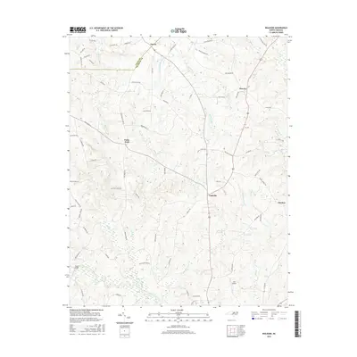
2016 Map of Ingleside
USGS Topo · Published 2016About this map
Ingleside and the surrounding rural communities of Franklin County are defined by the winding course of the Tar River as it cuts across the southern portion of this landscape. The terrain is a network of small creeks and drainages, including the evocatively named Devils Cradle Cr, Bear Swamp Cr, and Giles Little Mill Cr. Settlement patterns follow the higher ground between these waterways, with established crossroads such as Epsom, Kearney, and Moulton connected by a grid of local roads often named for resident families. Significant landmarks like Simms Bridge and the Ball Airport highlight the transport and infrastructure of this Piedmont region. The map captures the agricultural and residential character of the area, showing how localized water bodies like Strickland Pond and Lake View dot the countryside.
Find a feature on this map
78 named features on this map. Tap any name to fly to it.
Don’t see what you’re looking for? This feature index may not catch every label — zoom into the map to look around manually.
Map Details
Editions of this 2016 Ingleside Map
This is the sole edition of this map. No revisions or reprints were ever made.
Other maps of this area

1953 · Greensboro
USGS Topo · 1:250,000

1954 · Greensboro
USGS Topo · 1:250,000

1962 · Greensboro
USGS Topo · 1:250,000

1966 · Greensboro
USGS Topo · 1:250,000

1970 · Vicksboro
USGS Topo · 1:24,000

1970 · Henderson
USGS Topo · 1:24,000

1971 · Afton
USGS Topo · 1:24,000
1978 · Franklinton
USGS Topo · 1:24,000
1978 · Gold Sand
USGS Topo · 1:24,000
1978 · Louisburg
USGS Topo · 1:24,000