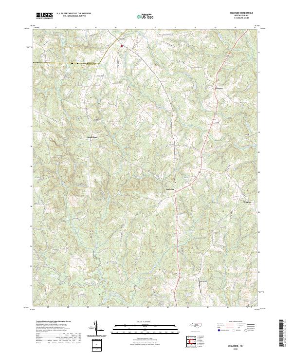
2022 Map of Ingleside
USGS Topo · Published 2022About this map
The Vance Co Franklin Co line bisects this landscape where the Tar River and Bear Swamp Cr define the drainage of the North Carolina piedmont. Small rural centers like Ingleside and Epsom serve as focal points for a network of secondary roads, many of which carry family names like Sollie Ayscue Rd and Frazier Dement Rd. These road names hint at the deep-rooted landownership patterns of the region. The terrain is characterized by a dense network of tributaries including Gills Little Mill Cr and the curiously named Devils Cradle Cr. In the northern section, Epsom and Kearney sit near the county boundary, while the southern reaches include Ball Airport and the waters of Strickland Pond. This survey provides a modern accounting of these established rural communities and the intricate creek systems that have shaped local agriculture and settlement for generations.
Find a feature on this map
76 named features on this map. Tap any name to fly to it.
Don’t see what you’re looking for? This feature index may not catch every label — zoom into the map to look around manually.
Map Details
Editions of this 2022 Ingleside Map
This is the sole edition of this map. No revisions or reprints were ever made.
Other maps of this area

1953 · Greensboro
USGS Topo · 1:250,000

1954 · Greensboro
USGS Topo · 1:250,000

1962 · Greensboro
USGS Topo · 1:250,000

1966 · Greensboro
USGS Topo · 1:250,000

1970 · Vicksboro
USGS Topo · 1:24,000

1970 · Henderson
USGS Topo · 1:24,000

1971 · Afton
USGS Topo · 1:24,000
1978 · Franklinton
USGS Topo · 1:24,000
1978 · Gold Sand
USGS Topo · 1:24,000
1978 · Louisburg
USGS Topo · 1:24,000