1930 Map of Inglewood
USGS Topo · Published 1930About this map
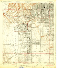
Inglewood and the surrounding Los Angeles basin are captured in 1930 as a landscape of rapid transformation, where Spanish land grant legacies like Sausal Redondo and Aguaje de la Centinela meet the burgeoning aviation and petroleum industries. This survey highlights a critical era for Southern California flight, documenting established hubs such as Mines Aviation Field and Kelly's Airport, alongside smaller facilities like Dycer Airport. The transition from agricultural use to urban residential blocks is evident in the emerging street grids of Lennox, Hawthorne, and Lawndale.
Find a feature on this map
47 named features on this map. Tap any name to fly to it.
Don’t see what you’re looking for? This feature index may not catch every label — zoom into the map to look around manually.
Map Details
Editions of this 1930 Inglewood Map
This is the sole edition of this map. No revisions or reprints were ever made.
Other maps of this area

1894 · Los Angeles
USGS Topo · 1:62,500

1896 · Redondo
USGS Topo · 1:62,500

1896 · Santa Monica
USGS Topo · 1:62,500

1898 · Santa Monica
USGS Topo · 1:62,500

1900 · Los Angeles
USGS Topo · 1:62,500

1901 · Southern California Sheet No. 1
USGS Topo · 1:250,000

1902 · Santa Monica
USGS Topo · 1:62,500

1904 · Southern California Sheet No. 1
USGS Topo · 1:250,000

1920 · Santa Monica
USGS Topo · 1:62,500

1921 · Santa Monica
USGS Topo · 1:62,500