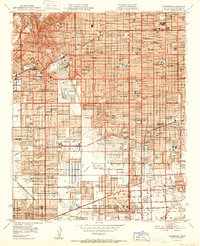
1952 Map of Inglewood
USGS Topo · Published 1952About this map
Inglewood Park Cemetery and the adjacent grounds of Hollywood Park anchor this 1952 study of a rapidly urbanizing Los Angeles basin. The landscape is defined by a dense grid of residential and commercial growth stretching from Inglewood down through Hawthorne and Gardena. This era captures the height of the region's aviation and education infrastructure, featuring the Gardena Valley Airport, Central Airport, and the campus of El Camino Jr College.
Find a feature on this map
122 named features on this map. Tap any name to fly to it.
Don’t see what you’re looking for? This feature index may not catch every label — zoom into the map to look around manually.
Map Details
Editions of this 1952 Inglewood Map
This is the sole edition of this map. No revisions or reprints were ever made.
Other maps of this area

1894 · Los Angeles
USGS Topo · 1:62,500

1896 · Pasadena
USGS Topo · 1:62,500

1896 · Redondo
USGS Topo · 1:62,500

1896 · Santa Monica
USGS Topo · 1:62,500

1896 · Downey
USGS Topo · 1:62,500

1898 · Santa Monica
USGS Topo · 1:62,500

1899 · Downey
USGS Topo · 1:62,500

1900 · Pasadena
USGS Topo · 1:62,500

1900 · Los Angeles
USGS Topo · 1:62,500

1901 · Southern California Sheet No. 1
USGS Topo · 1:250,000