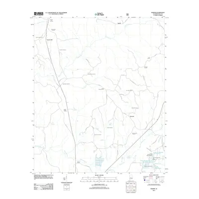
2011 Map of Ingram
USGS Topo · Published 2011About this map
Whitsitt-Perry Cemetery and Pruit Springs Cemetery stand on the northern edge of this Hale County landscape, marking the legacy of long-standing local families. The terrain near Harper Hill is defined by the winding paths of Fivemile Creek and Harry Branch, which flow through a countryside heavily marked by community burial grounds and chapels. Small settlements like Dominick and Ingram anchor a network of rural routes, including Ramey Rd and Co Rd 32. To the south, the geography shifts toward water management and recreation at Lenson Montgomery Lake Number 1 and Murphy Averette Lake. The presence of the Havana Lookout Tower overlooking the western reaches suggests the importance of forestry and fire surveillance in this corner of Alabama during the early 21st century.
Find a feature on this map
60 named features on this map. Tap any name to fly to it.
Don’t see what you’re looking for? This feature index may not catch every label — zoom into the map to look around manually.
Map Details
Editions of this 2011 Ingram Map
This is the sole edition of this map. No revisions or reprints were ever made.
Other maps of this area

1953 · Montgomery
USGS Topo · 1:250,000

1956 · Montgomery
USGS Topo · 1:250,000

1957 · Montgomery
USGS Topo · 1:250,000

1979 · Morgan Springs
USGS Topo · 1:24,000

1979 · Greensboro
USGS Topo · 1:24,000

1980 · Payne Lake
USGS Topo · 1:24,000

1980 · Ingram
USGS Topo · 1:24,000
1980 · Moundville West
USGS Topo · 1:24,000
1980 · Sawyerville
USGS Topo · 1:24,000
1980 · Hogglesville
USGS Topo · 1:24,000