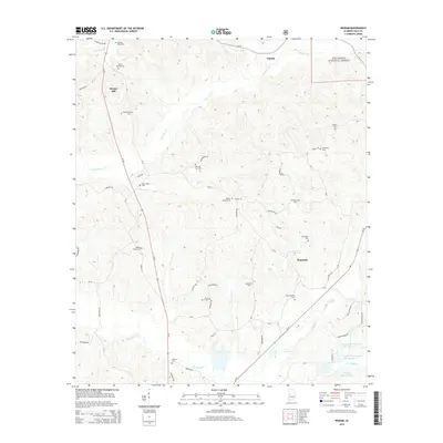
2014 Map of Ingram
USGS Topo · Published 2014About this map
Talladega National Forest encompasses the northeastern corner of this landscape, where the terrain transitions into the creek valleys of Hale County. The area is defined by a high density of small family and church burial grounds, suggesting a deeply rooted rural community structure. Notable sites include Saint Johns Cem and Pruitt Springs Cem, alongside the Morning Star Cem and Ramey Chapel Cem. The settlement at Harper Hill sits along Al-69, while Dominick serves as a local hub further south near Sparks Cr. The hydrography of the region is dominated by winding waterways like Fivemile Cr and Big Brush Cr, which fed localized water management as seen in Lenson Montgomery Lake Number 1 and Murphy Averette Lake. This network of roads and small settlements reflects a persistent agrarian character typical of the Alabama Black Belt hinterlands.
Find a feature on this map
67 named features on this map. Tap any name to fly to it.
Don’t see what you’re looking for? This feature index may not catch every label — zoom into the map to look around manually.
Map Details
Editions of this 2014 Ingram Map
This is the sole edition of this map. No revisions or reprints were ever made.
Other maps of this area

1953 · Montgomery
USGS Topo · 1:250,000

1956 · Montgomery
USGS Topo · 1:250,000

1957 · Montgomery
USGS Topo · 1:250,000

1979 · Morgan Springs
USGS Topo · 1:24,000

1979 · Greensboro
USGS Topo · 1:24,000

1980 · Payne Lake
USGS Topo · 1:24,000

1980 · Ingram
USGS Topo · 1:24,000
1980 · Moundville West
USGS Topo · 1:24,000
1980 · Sawyerville
USGS Topo · 1:24,000
1980 · Hogglesville
USGS Topo · 1:24,000