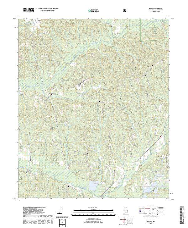
2024 Map of Ingram
USGS Topo · Published 2024About this map
Harper Hill and the surrounding Hale County countryside are defined by a network of family cemeteries and small rural congregations, many situated along the ridges of the Talladega National Forest. This landscape is heavily shaped by the drainage patterns of Fivemile Creek and Sparks Creek, which weave through the hilly terrain between AL Highway 69 and the eastern forest boundary. The map reveals a high concentration of burial grounds, such as Whitsitt Perry Cem and Pruitt Springs Cem, which serve as vital markers for genealogical research in this part of Alabama. To the south, the terrain transitions into a more modified landscape featuring Lenson Montgomery Lake Number 1 and Murphy Averette Lake, reflecting local water management and land use within the township and range system.
Find a feature on this map
61 named features on this map. Tap any name to fly to it.
Don’t see what you’re looking for? This feature index may not catch every label — zoom into the map to look around manually.
Map Details
Editions of this 2024 Ingram Map
This is the sole edition of this map. No revisions or reprints were ever made.
Other maps of this area

1953 · Montgomery
USGS Topo · 1:250,000

1956 · Montgomery
USGS Topo · 1:250,000

1957 · Montgomery
USGS Topo · 1:250,000

1979 · Morgan Springs
USGS Topo · 1:24,000

1979 · Greensboro
USGS Topo · 1:24,000

1980 · Payne Lake
USGS Topo · 1:24,000

1980 · Ingram
USGS Topo · 1:24,000
1980 · Moundville West
USGS Topo · 1:24,000
1980 · Sawyerville
USGS Topo · 1:24,000
1980 · Hogglesville
USGS Topo · 1:24,000