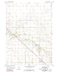
1958 Map of Inman
USGS Topo · Published 1986About this map
The village of Inman serves as the central hub of this Nebraska landscape, situated at a junction where the Chicago and North Western and Burlington Northern railroads converge. The meandering path of the Elkhorn River cuts across the terrain, flanked by the seasonal drainage of Dry Creek. This 1958 survey, with revisions through the mid-1980s, captures a rural economy built on agriculture and local infrastructure, visible in the distribution of rural schoolhouses like School No 17 and School No 5. Communication and industrial footprints are evident through the presence of a TV Tower and several Gravel Pits. The settlement pattern reflects the reliance on rail transport and the natural corridor of the river valley, providing a detailed look at Holt County’s developmental layout during the late twentieth century.
Find a feature on this map
14 named features on this map. Tap any name to fly to it.
Don’t see what you’re looking for? This feature index may not catch every label — zoom into the map to look around manually.
Map Details
Editions of this 1958 Inman Map
2 editions found
Other maps of this area

1954 · Dorsey SW
USGS Topo · 1:24,000

1954 · Opportunity
USGS Topo · 1:24,000

1954 · Meek SW
USGS Topo · 1:24,000

1955 · O'Neill
USGS Topo · 1:250,000

1958 · O'Neill
USGS Topo · 1:24,000

1958 · Inman
USGS Topo · 1:24,000

1958 · Page
USGS Topo · 1:24,000

1959 · O'Neill
USGS Topo · 1:250,000

1963 · Ewing SW
USGS Topo · 1:24,000

1964 · O'Neill SE
USGS Topo · 1:24,000