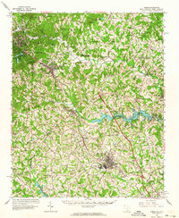
1961 Map of Inman
USGS Topo · Published 1964About this map
The Southern Railway corridor serves as the industrial and social backbone for this region along the South Carolina and North Carolina border in the early 1960s. The textile industry’s footprint is evident at Inman Mills, a concentrated industrial settlement situated just south of the established town of Inman. This area is defined by the transition from the foothills of the Blue Ridge, where Little Mountain and Bird Mountain rise, toward the developing water infrastructure of the Piedmont. Significant hydrological features including the Lake William C Bowen and the South Pacolet River Res No 1 indicate the mid-century expansion of water resources for the growing populations of Spartanburg and Greenville counties. Rural life is anchored by numerous community landmarks such as Chapman High Sch and a dense network of country churches like Jackson Grove Ch and Mt Zion Ch.
Find a feature on this map
69 named features on this map. Tap any name to fly to it.
Don’t see what you’re looking for? This feature index may not catch every label — zoom into the map to look around manually.
Map Details
Editions of this 1961 Inman Map
This is the sole edition of this map. No revisions or reprints were ever made.
Other maps of this area

1907 · Saluda
USGS Topo · 1:125,000

1935 · Greer
USGS Topo · 1:48,000

1935 · Greenville
USGS Topo · 1:48,000
1935 · Fishtop
USGS Topo · 1:24,000

1938 · Greenville
USGS Topo · 1:62,500

1938 · Greer
USGS Topo · 1:62,500

1941 · Spartanburg
USGS Topo · 1:250,000
1946 · Cliffield Mtn
USGS Topo · 1:24,000
1947 · Cliffield Mtn.
USGS Topo · 1:24,000

1947 · Spartanburg
USGS Topo · 1:62,500